Operations

Launch ~~~~ Ground Control Station ~~~~ Recovery

Launch

The launch team is responsible for filling the latex balloon with helium and ensuring the lift is correct for the desired rate of rise. The launch team is also responsible for properly connecting the balloon, parachute and payload package together with nylon cord. After checking with ground control that the payload is functioning 100% and ready for launch, the launch team is then responsible for launching the balloon with it's payload after ensuring it will safely clear all nearby ground obstacles as it begins its assent.

Ground Control Station

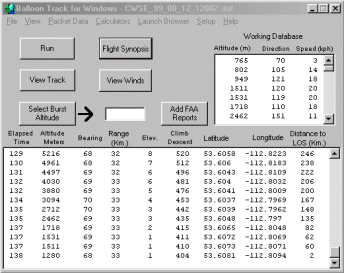
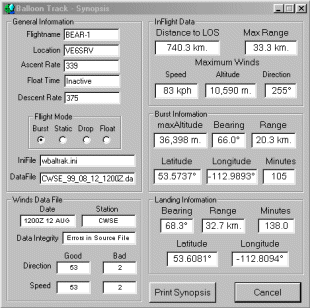
Before a launch, the Ground Control Station is responsible for predicting the landing area.

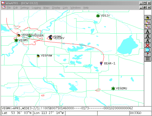
After a launch, the Ground Control Station is responsible for:

  • tracking the balloons location,
  • continuously refining the predicted landing area as telemetry data is received,
  • keeping recovery teams informed of the current balloon location and predicted landing area,
  • collection and logging of all telemetry data,
  • payload operation, and
  • the sharing of all information to anyone interested via the BEAR web site.

Depending upon the payload, payload operation may include control of onboard cross-band repeater radio traffic, of video and still frame cameras, of cut down mechanism, etc. Similarly, the sharing of information via the internet may include streaming audio of cross-band repeater radio traffic, live video, still photos, and status reports in addition to telemetry data.

Balloon Tracking

The control station tracks balloon flights using APRS telemetry data to generate flight path displays like this one of the BEAR-1 flight.

WinAPRS in action

Payload Landing Site Prediction

Wind Data and raw output windows

Flight Synopsis

Balloon Track for Windows software using weather office winds aloft data plus lift and descent rates for our balloon package is used to predict the payload landing area before launch. After launch, during the ascent portion of the mission, the weather office data is continuously updated using collected telemetry data to refine the predicted payload landing site. Immediately after the balloon bursts a final prediction is made.

Just prior to launch, weather office winds aloft data is used to help decide upon an assent rate. If the predicted landing area is near, a slow assent rate will be chosen to maximize flight time. However, if the predicted landing area is distant, then a faster assent rate will be chosen to reduce the distance recovery teams must travel in order to retrieve the payload.

Recovery

Recovery of the balloon payload is the most critical portion of the mission as it's required to recover expensive equipment required for subsequent launches and any camera images. WinAPRS in actionSome recovery teams will use the balloons APRS telemetry data to provide a real time moving map display on a laptop computer in the chase vehicle to track the payload. Coordination between chase vehicles, base tracking stations and the ground control station will be through a payload cross-band repeater, local repeaters or on a simplex frequency as need be.

APRS tracking data allows real time mapping of the balloons course during the flight, but backup methods to track the payload must be in place if the APRS system fails. One method is for mobile trackers and fixed base stations with directional beam antennas to use RDF (radio direction finding) techniques to monitor payload signals and determine it's position.


To BEAR Home Page